

Reaching new heights with GeoFM
Challenge closed
Producing accurate Digital Surface Models (DSM) and Digital Terrain Models (DTM) with ground cover information at a global scale remains a major challenge. Traditionally, these datasets rely on expensive airborne LiDAR surveys, which are not available everywhere.
To tackle this issue, for the first time ever, ESA Φ-lab Challenges partners with the International Telecommunication Union (ITU) and AI for Good, to present a new instance in the GeoAI series. The joint "Reaching new heights with GeoFM" Challenge, marks an important step toward creating a global mapping of surface heights and land‑cover classes using only open‑access satellite imagery.
By leveraging publicly available multispectral and SAR missions (particularly those from ESA’s Earth Observation portfolio) the effort aims to democratise access to elevation and land‑cover information that is typically restricted to well‑funded national or commercial programmes.
A global, open, and regularly updated DSM–DTM–land‑cover dataset would directly support a wide range of applications aligned with the UN Sustainable Development Goals (SDGs). These include sustainable urban planning (SDG 11), climate resilience and disaster‑risk reduction (SDG 13), improved monitoring of forests and ecosystems (SDG 15), and more efficient water and land‑resource management (SDGs 6 and 2).
While one of the objectives is to advance EO‑based geospatial datasets for global sustainability, the outcomes can also support organisations such as the International Telecommunication Union (ITU), where improved surface and terrain information enhances the accuracy of radio‑wave propagation models and supports more efficient spectrum‑management practices.
Your mission: Reaching new heights with GeoFM embeddings
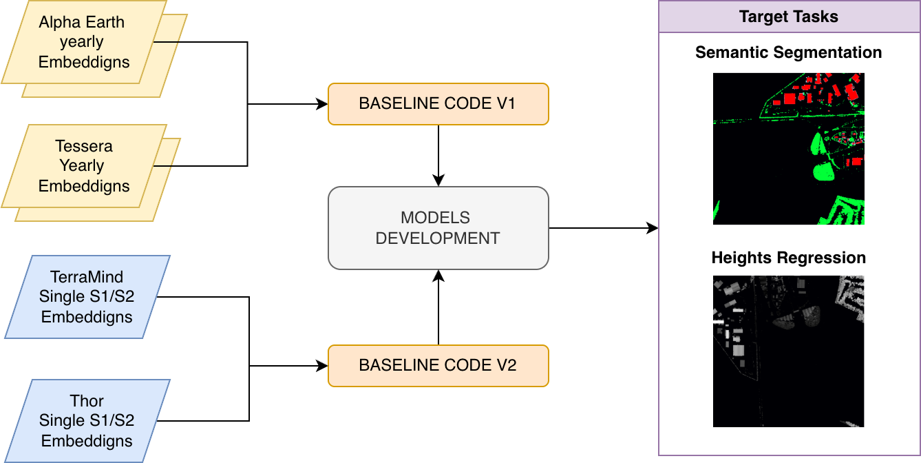
The objective of this challenge is to investigate how embeddings generated by state-of-the-art Geospatial Foundation Models (GFMs)- including AlphaEarth, Tessera, and ESA-empowered TerraMind and THOR- can be leveraged for multi-task learning.
Participants will be provided with pre-computed embeddings from multiple geospatial foundation models and tasked with developing models that can effectively merge and utilize these embeddings to:
1️⃣ Perform segmentation of buildings and vegetation
2️⃣ Predict building and vegetation heights
This challenge offers a unique opportunity to explore 3D semantic segmentation and height estimation using foundation model representations. Participants are encouraged to experiment with innovative architectures, feature engineering approaches, and data fusion strategies to effectively combine the embeddings and achieve strong performance.
Your timeline:
- Launch: 8th April 2026
- Educational webinar: 8th April 2026, 14:00 CEST
- Closing: 30th June 2026
- Award ceremony (AI for Good Global Summit): 7th –10th July 2026
The Challenge at a glance:
Still on the fence whether you should join?
📖🌍 Learning beyond local context, by designing models that perform robustly across regions and environments;
🔬 🖥️ Multi-task problems, blending regression tasks (e.g. height estimation of buildings and vegetation) with segmentation tasks (e.g. ground or cover type);
🤖💽 Foundation-model-driven workflows, encouraging creative use of GeoFM embeddings;
🌱💪 Meaningful impact, linking technical performance to globally relevant challenges aligned with the UN Sustainable Development Goals (SDGs);
💶🏆 Recognition beyond cash prizes, offering both financial awards and exposure to a global network of geospatial and AI experts.
Get ready!
Check out the other pages for a full overview of the data, rules, and prizes!